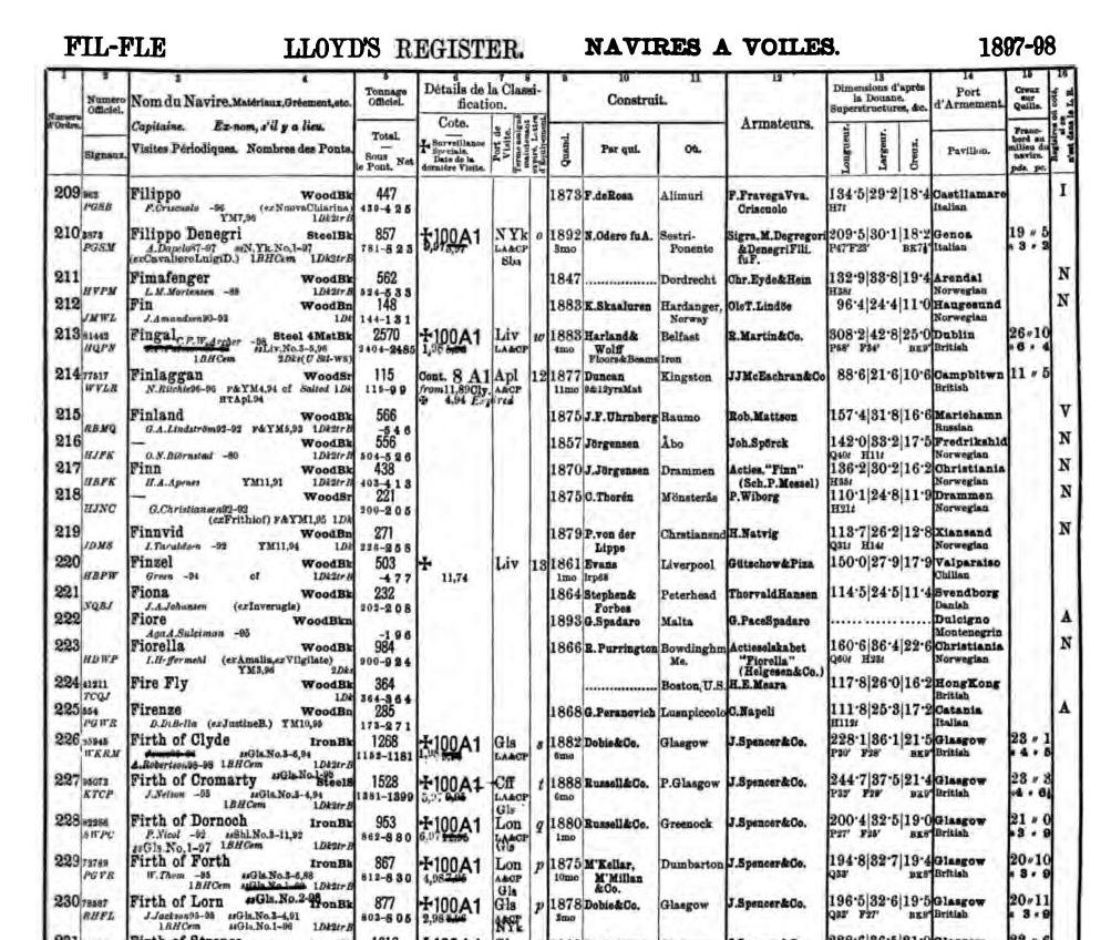
The iron barque Firth of Cromarty was was launched from the Port Glasgow yard of Russell & Company Ltd (Yard No 185) on 12th June 1888. She measured 244.7′ x 37.5′ x 21.4′ and her tonnage was 1528 gross tons. Built for James Spencer and Co Ltd (The Firth Line) she was first registered in Glasgow on 17th July 1888.

Firth of Cromarty under tow
The Firth of Cromarty departed from Glasgow on Saturday 26th August, 1898 bound for Sydney and Newcastle, New South Wales with around 2250 tons of general cargo. She was towed as far as Rothesay by the tug Defender where she dropped anchor around midnight. Shortly after 6am the following morning the two vessels left Rothesay and by 8pm they were passing Ailsa Craig where, with a favourable wind, the barque dropped her tow and set sail.
She headed south for the Irish Sea, sighting Corsewall Lighthouse around 9pm. Two hours later she was close inshore, off Corsewall Point, with her crew on deck ready to ‘wear ship’ when the strong north westerly wind suddenly veered round to the south west. Her sails flapped uselessly in the wind and, as the crew struggled to regain control and steerage, her stern grounded on the rocks at Bloody Point and she held fast. The barque shuddered several times as the large breakers bounced her on the rocks before she swung round, beam on to the sea, and canted over on her starboard side. Parts of the rigging and spars rained down on the crew as they ran to find shelter from the waves breaking over the main deck. The only shelter available was the forecastle and poop decks, where the crew remained, cold and wet, throughout the night.
By daybreak the weather had greatly improved. The crew managed to launch the port lifeboat and, with ten men aboard, headed off to find help. The lifeboat, under the charge of the first mate, John McMillan, eventually landed in Loch Ryan where they were looked after by a local farmer. The remainder of the crew were rescued by Portpatrick Rocket Brigade later that morning.

Firth of Cromarty aground at Bloody Point
The wreck was soon visited by both the Glasgow and Liverpool Salvage Associations but, owing to bad weather, they were unable to board her until 31st August. They immediately discovered that the Firth of Cromarty had broken her back – she was a total wreck. In the intervening period her decks had burst open and large quantities of her gear and cargo, which included whisky, beer, iron, crockery, haberdashery and preserves, were washed ashore along the adjacent coastline. Salvage work commenced on 1st September with the arrival of the steamers Stormlight and Sealight and, over the next four weeks, a substantial portion of her cargo was saved and shipped to Glasgow. The wreck was eventually abandoned at the end of September 1898 and soon disappeared, pounded by yet another storm on this exposed coastline. At a subsequent enquiry her master, James Nelson, was found in default for the loss of the barque and his master’s certificate was suspended for six months.

The wreck of the Firth of Cromarty lies in approximate position 55° 00.025’N, 005° 10.242’W, 500 metres north east of Oust Rocks. The remains are scattered among gullies and at the base of the rock shelf in 8 to 10 metres. Sections of hull and mast can be seen but otherwise she is completely broken.
Firth of Cromarty slideshow


Parts of her cargo can be found surrounding the wreckage welded into clumps or sometimes lying loose in corners. The wreck is best approached by sea from launch sites in Loch Ryan or Dally Bay, two miles south, although launching here is across a sandy beach via a narrow winding track from the main road. Strong tidal streams can be expected in this area on spring tides.

Location chart.
We would like to thank Lloyd’s Register Foundation – Heritage & Education Centre for allowing us to reproduce documents from their archive in this article.


