Throughout the history of Clyde navigation few storms have been more destructive than the hurricane which swept across southern Scotland during the early hours of Saturday 22nd December, 1894. Many vessels were wrecked along the Clyde coast with eleven being recorded in the Galloway region alone.
Profile plan SS Oswald (Lloyds Register Foundation)
Lloyds register 1894
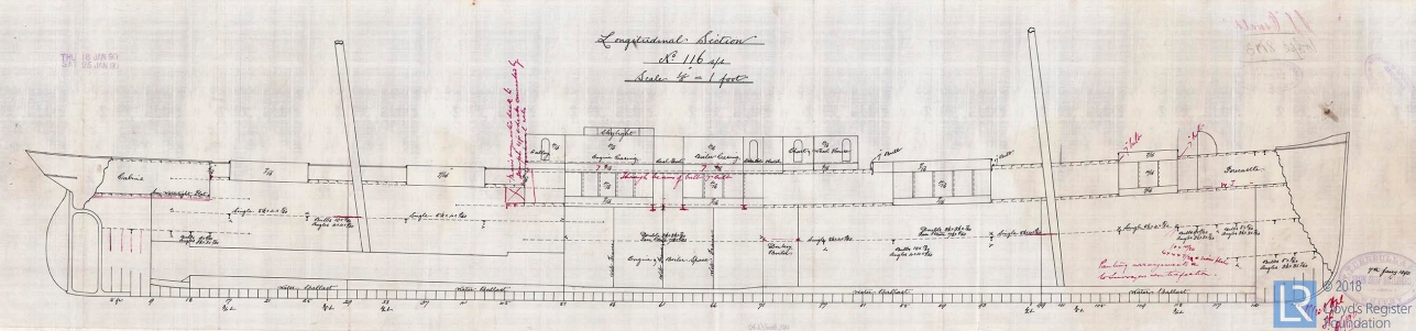
The most disastrous casualty to occur along this stretch of coastline was the loss of the Whitby registered iron steamship Oswald, with her crew of nineteen, while on a voyage from Londonderry to Cardiff. The Oswald was launched on 3rd July 1890 from the yard of Thomas Turnbull & Son Ltd of Whitby (Yard No.116). This company also owned and operated the vessel as a general cargo steamship. The ship’ s measurements were 258.5′ x 37.2′ x 18.1′ and her tonnage was 1835 gross and 1157 net. Her triple expansion steam engine was manufactured by Blair & Co. Ltd of Stockton on Tees and delivered 170 nominal horse power. The ship’ s official number was 96554.

SS Fairmead built by Turnbull & Son , launched April 1890 but 31′ longer than the Oswald

The Oswald was driven ashore sometime after midnight on 22nd December and, due to the intensity of the storm, only part of her boiler remained above water level when the wreck was discovered near Port Gill around 9am the next morning. The surrounding coastline was strewn with debris and it was not until pieces of wreckage were found bearing her name that the identity of the lost ship was established.

Her loss was the subject of a Board of Trade enquiry which concluded that, as she was travelling in ballast, her draught was substantially reduced and as a result her propeller and rudder would have had little effect in the prevailing weather conditions and, as such, she would have been totally out of control.


We would like to thank Lloyds Register Foundation (hec.lrfoundation.org.uk) for their permission to use their documents on our website


