Built for the Baltimore Storage and Lightering Company of London the steel steamship Swansea was launched on 8th June 1887 from the yard of William Gray and Company of Hartlepool (Yard No 322). She measured 315.2′ x 40.2′ x 20.2′ her tonnage was 2816 gross tons, 1690 net tons. She was powered by a triple expansion steam engine of 274 nominal horse power supplied by the Central Marine Engineering Works of Hartlepool. The vessel was sold only a year later, renamed Maine and operated for the Maine Steamship Company until purchased by the Atlantic Steamship Company in 1891. Her official number was 94303.
In 1901 she was requisitioned by the Admiralty and converted to a hospital ship. As the First World War approached Maine, which had spent most of her Admiralty career in the Mediterranean, arrived in Lamlash, Arran in support of a number of warships stationed there.

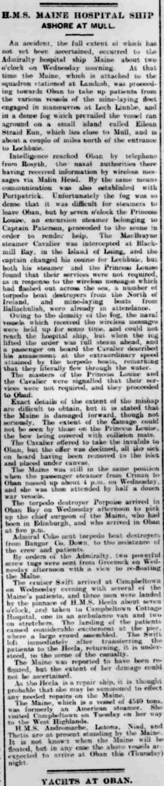
RFA Maine at anchor
In June 1914 she sailed from Lamlash, via Campbeltown, to pick up patients from the minelaying fleet engaged in manoeuvres in Loch Linnhe. As she steamed into the Firth of Lorne on the 16th she was enveloped in dense fog and, as a result, she ran aground at around 2am the next morning on the Mull coast close to Frank Lockwood’s Island. Their was no panic aboard as it was obvious that she was in no immediate danger allowing the crew to begin an orderly evacuation of the patients. They were taken ashore and housed in tents which had been erected to give them shelter while they awaited rescue. As soon as the fog cleared a number of naval vessels headed for the scene and by mid afternoon six ships were standing by off shore and the evacuation of the patients for transportation to Oban had begun. At first, it was hoped that the Maine could be refloated but, after examination, it was decided that the salvage would be too costly as she was seriously damaged and would almost certainly sink if she was pulled off unless extensive repairs were carried out on site. She was abandoned and was broken up where she lay after the war.

Maine aground at Frank Lockwood’s Island
Oban Times 20th June 1914
Some remains of the Maine can be seen ashore on the Mull coast behind Frank Lockwood’s Island. The Hydrographic Department have her charted at 56° 18.633’N, 005° 50.335’W. There are reports of scattered wreckage underwater but the authors could not find any signs of this when they dived in this location.


